Superbowl Sunday Storm

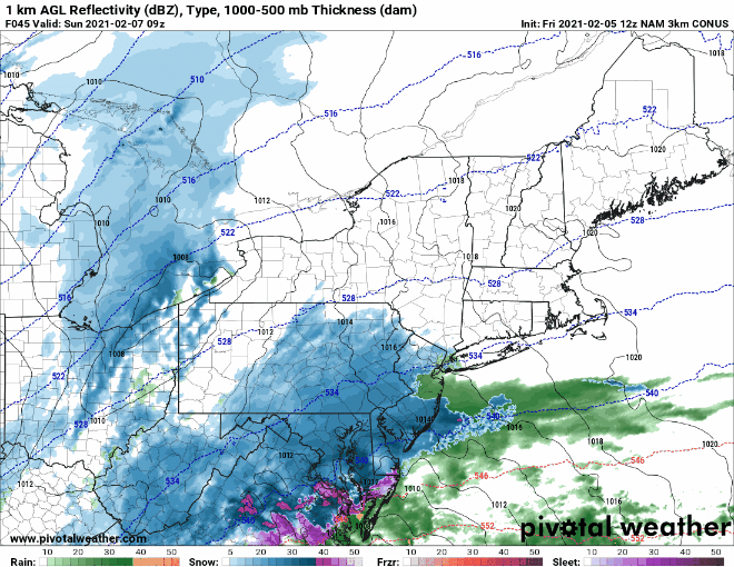
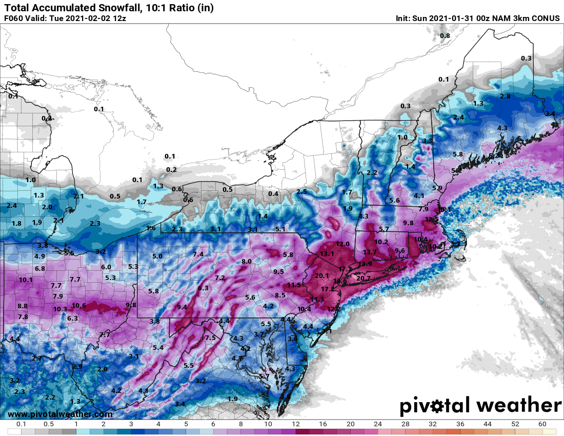
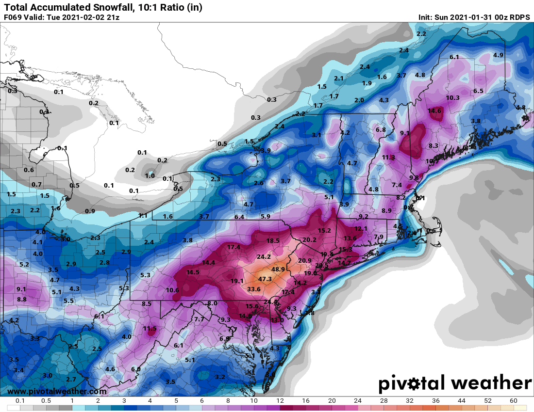
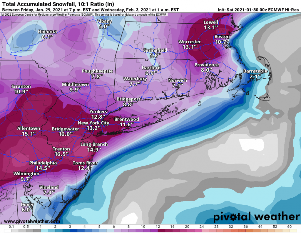
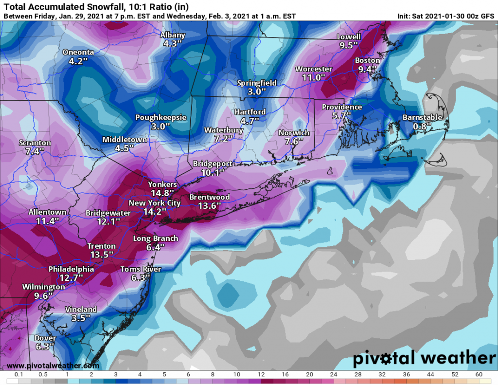
In what has come as a bit of a surprise it looks like our area will be impacted by a snowstorm beginning on early Sunday morning. As recently as yesterday morning the storm was looking to track far off the eastern seaboard. However, with yesterday’s model runs and continuing in to today, models are indicating that we will in-fact be impacted by the system.

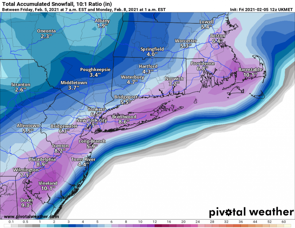
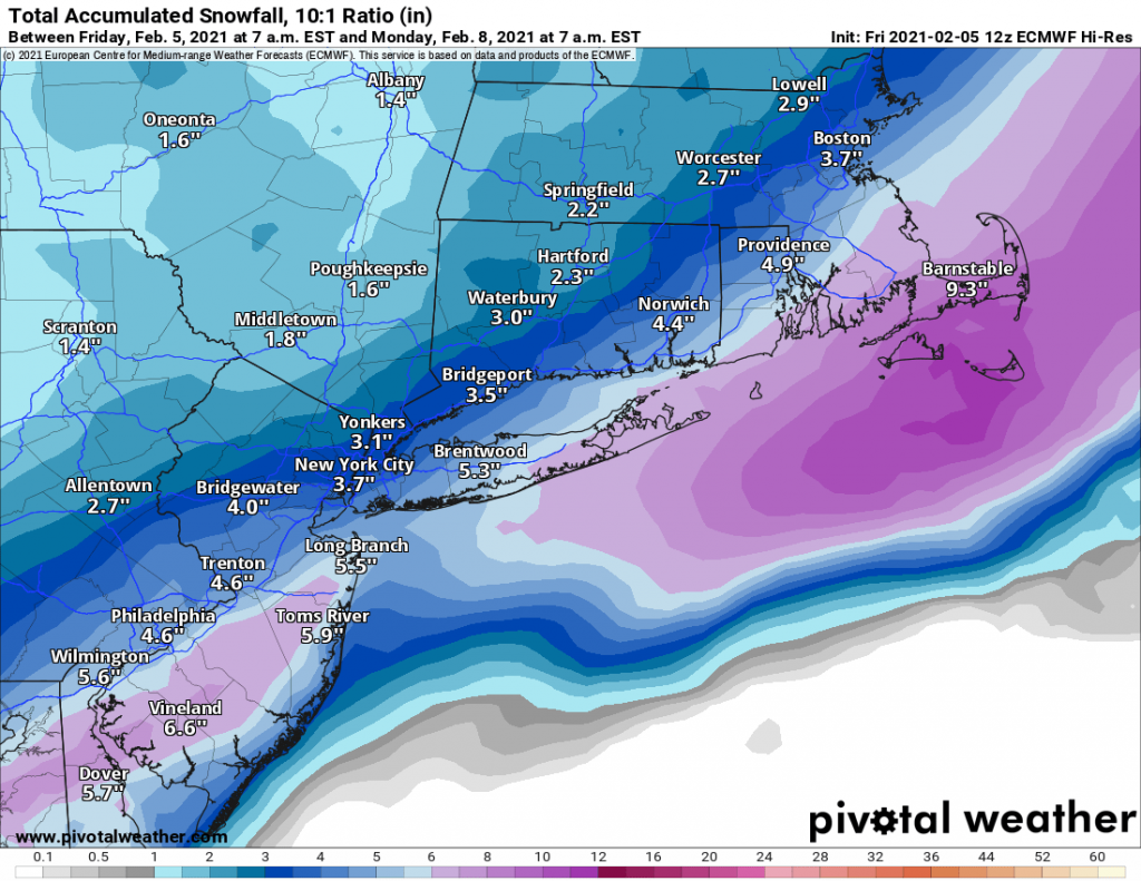
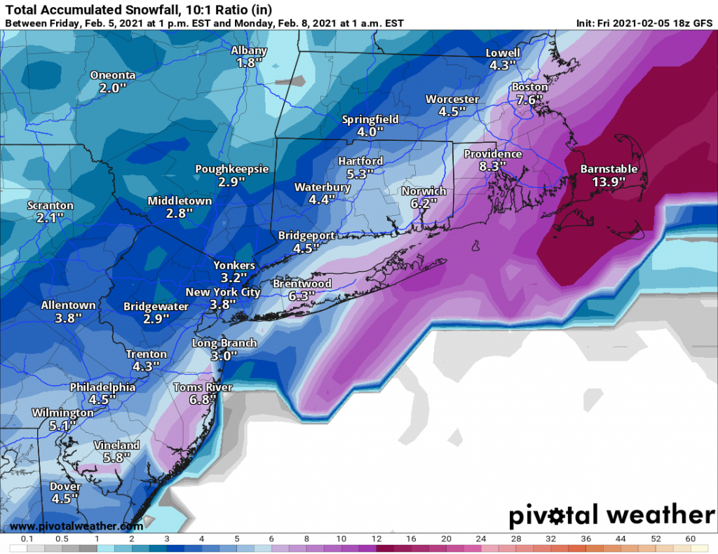
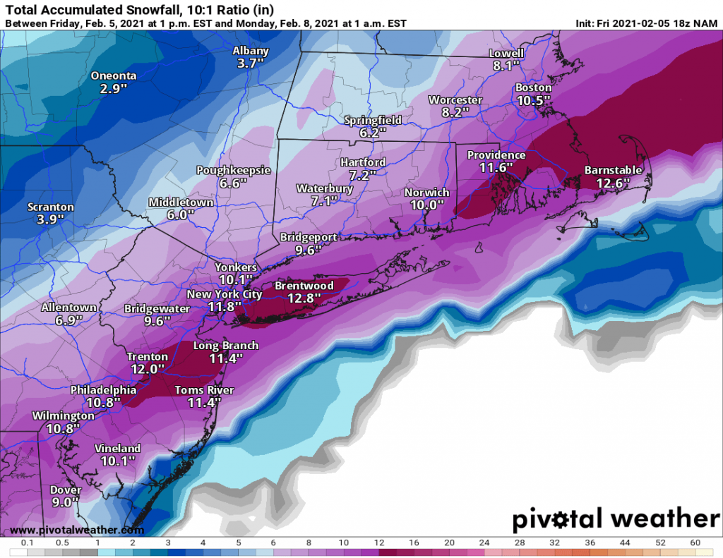
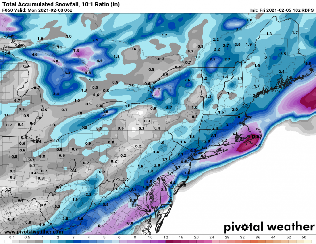
As of now there are two camps, one that brings anywhere from 4-8 inches of snow to our area by early Sunday evening. The other camp led by the NAM brings closer to a foot of snow to Long Island with slightly less in NYC and areas North and West. 

For now, I am predicting a general 4-8 inches of snow area wide, with the snow beginning before sunrise on Sunday and ending in the late afternoon before kick-off of the Superbowl. We will have to keep an eye on the trends tonight and tomorrow as another bump Northwest in the track would solidly put the region in the 8-12+ range.


1/31/21 Storm Update

We continue to be on track for a significant storm to impact our region beginning later this afternoon. As I indicated last night, and confirmed by overnight model runs and model runs this morning, expected snowfall has increased. As of this morning, all models have come in to alignment for a regionwide snowfall of 15-20″+. Parts of NYC and areas north and west likely will see over 20″ with some areas of interior NJ receiving as much as 30″. 

Snow should begin to overspread the region by late this afternoon in to early evening, it will continue overnight tonight and taper off sometime on Tuesday morning. During the day into the evening on Monday snowfall rates may exceed 2-3″ per hour with whiteout conditions. Additionally, winds especially on Long Island may gust over 40-50 MPH.

This will be by far the largest and most impactful snowstorm our area has seen in several years.

1/31 Storm Update

Just a quick update as the models start to roll in for the night:

The NAM and RGEM just came in and changed the ballgame for how much snow may be looking at with both showing AT LEAST 15-20” if not more area wide. There are still several other models left to run this evening, and I am not yet ready to change my final call but be aware that we may be looking at more snow than initially expected. I’ll post a final call in the morning based on the overnight modeling and trends that we are seeing…

1/31/21-2/2/21 Storm

Sorry for the delay in providing updates, I have been actively tracking the storm but life has gotten in the way of posting updates. But do not fear, I will be with you throughout this weekend. (Sorry to my wife and daughter for disappearing to track this weekend.) This storm is lining up to be a classic for our area, with a key difference being the duration. In recent years our storms have been in and out in under 12 hours. However, this one looks to be a long duration event starting late Sunday evening and continuing through Tuesday morning. As a matter of fact, some models including the latest NAM run are indicating snow will continue through midday Tuesday. 

Overall this storm will drop anywhere from 10-15 inches regionwide, with the potential for some areas to exceed 15″ depending on where banding sets up. By the way of example, the 3K NAM out to the end of it’s run at hour 60 has around 15 inches of snow for Long Island, and it is still snowing at that time indicating the chance for some areas to possibly hit 20″. However, at this time there is limited support for that outcome with only the Parallel GFS model supporting this outcome. The regular GFS and EURO models both are in the 10-15 range for our region. 

I will keep you updated as more model runs come out later today and we start zeroing in on where the banding will setup. 

12/16/2020 Storm Update- Forecast Mayhem

Today has been a wild day in storm tracking. We went from the totals exceeding 12-16″ on models for our region this weekend to some models this morning showing only 2-4″ this morning. It all comes down to just how far north the low pressure system tracks tomorrow evening in to Thursday. A shift of 25-50 miles means the difference between Long Island seeing 4-8″ of snow and seeing 6-12″+ of snow. As of this evening I am leaning towards the 4-8″ camp of models based on climatology and modeled evolution of the low pressure system. However, today has shown this is subject to significant change tomorrow morning and afternoon. 

Timing of the system arriving remains the same with snow overspreading our region by late afternoon and early evening tomorrow. It is still expected that we will see heavy snowfall rates over-night potentially exceeding two inches an hour. The biggest area of uncertainty comes overnight where some models are tracking the low close to the south shore of Long Island, leading to Long Island and possibly NYC to change over to sleet and/or rain for a few hours. Afterwards a second band of light snow is expected, and this may lead to a few more inches of accumulation. 

Forecast Totals:

Suffolk: 3-6″
Nassau: 4-8″
Queens and Brooklyn: 6-10″
Areas north and west of NYC: 8-14″

Overall this will be an impactful system that will disrupt Thursday mornings commute. Even if we are on the low end of the snowfall forecast, the snow itself will be heavy and hard to clear due to the potential sleet and rain mixed in. 

I am holding back on posting further snow-maps this evening as they are truly all over the place, and not indictive of what to expect tomorrow and Thursday.