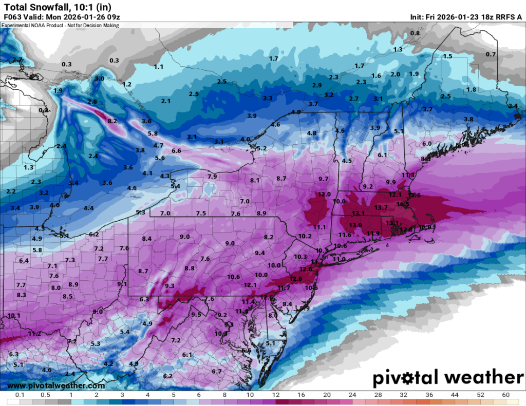
As of this morning, everything is on track for a historic system to impact our region today and tomorrow. Snow should begin overspreading the area by early this afternoon and continue through tomorrow morning. By the time it ends, I expect most of us to see at least 20″ of accumulation. I wouldn’t be shocked if localized areas received over 25″, but that is impossible to predict right now as it all depends on where the heavy banding sets up. The other notable feature of this event will be the wind; at the height of the storm overnight, gusts will exceed 50 mph. This will undoubtedly be an event we remember for a long time.
While you’re safely inside riding out the weather, make sure to tune in and support Team USA this morning against Canada!
With the runs over night, the models have locked in. What was a highly uncertain situation just 24 hours ago has come into much clearer focus, and the picture they’re painting is significant. This will be the most impactful snowstorm our area has seen in years. Our whole area is now under Blizzard Warnings that take effect tomorrow morning.
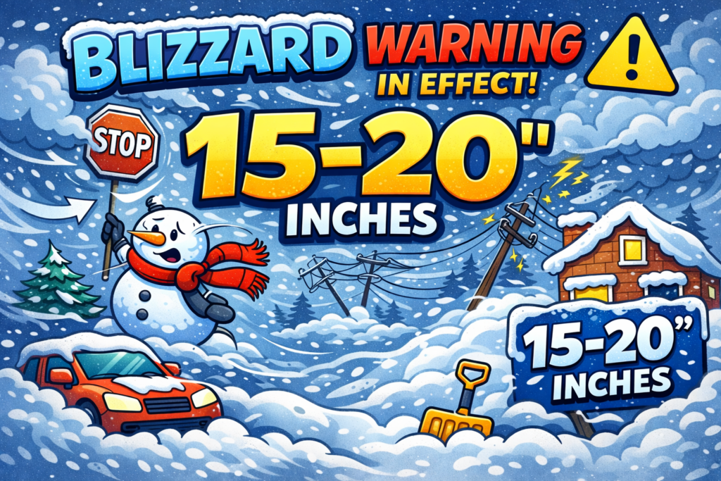
TLDR: Expect 15–20″ of snow area-wide, blizzard conditions for several hours, and wind gusts exceeding 50 mph. HEAVY snow develops Sunday afternoon and continues through Monday morning.
What the Models Are Saying
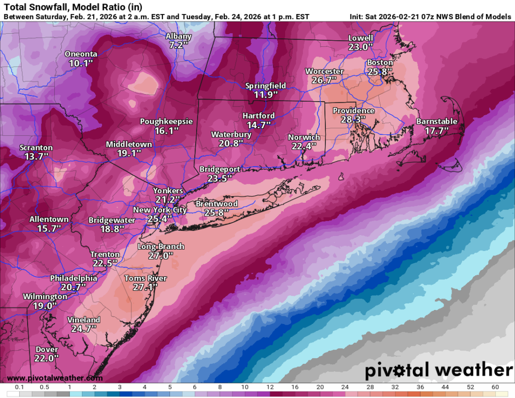
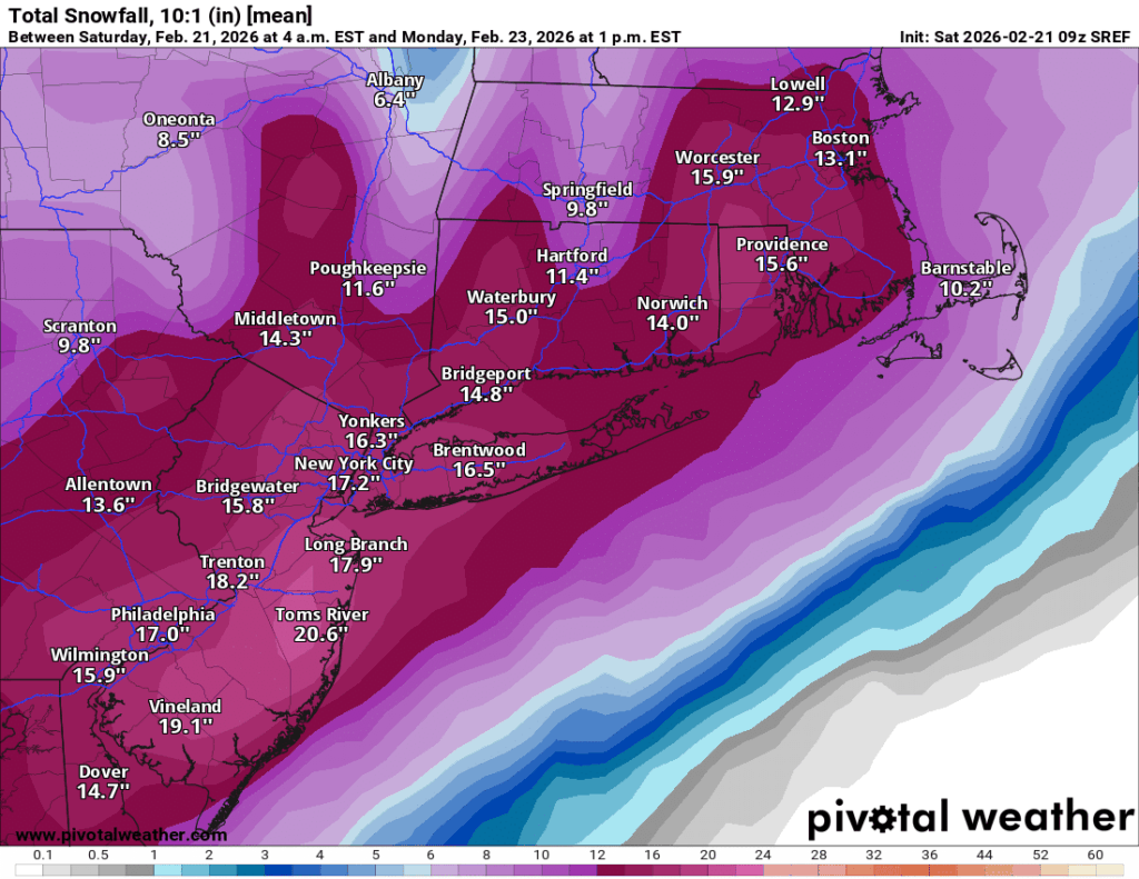
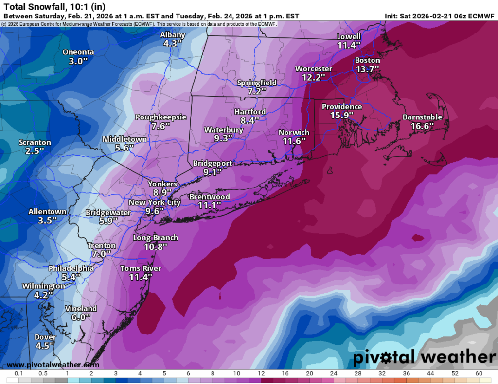
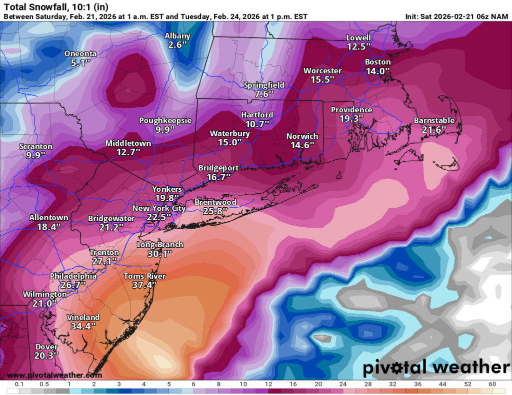
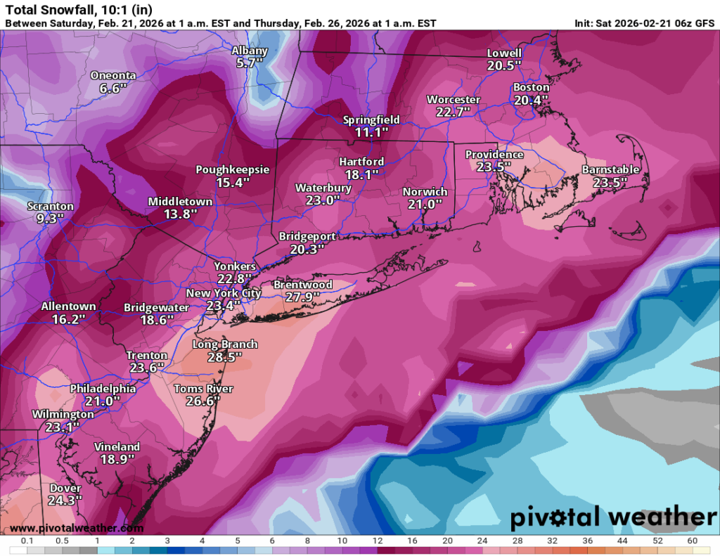
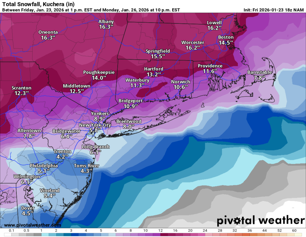
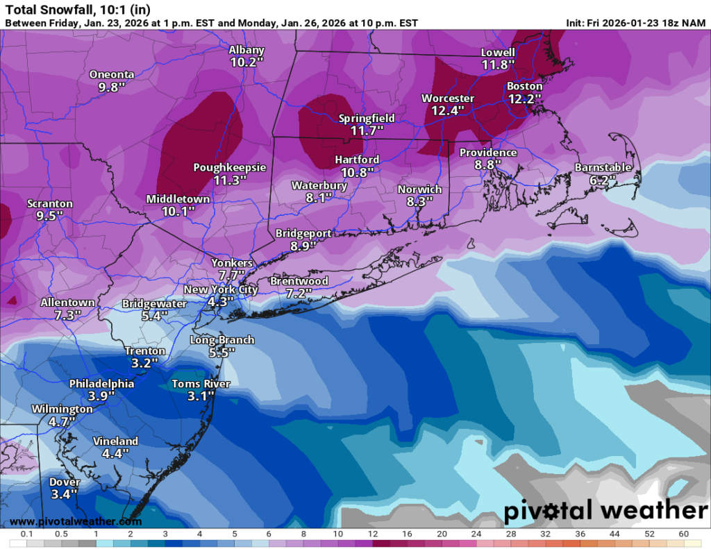
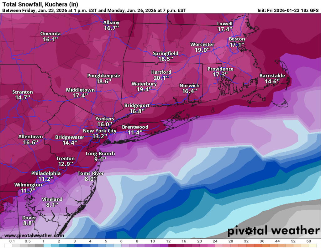
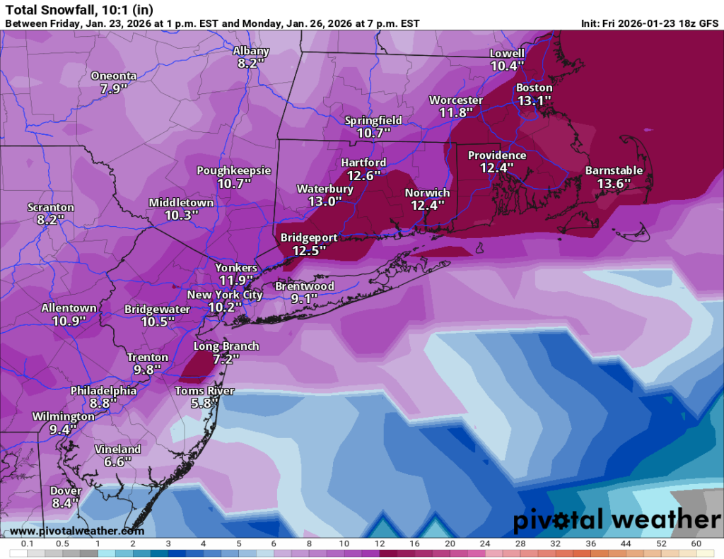
The model spread has tightened considerably, though there’s still a meaningful range. Here’s where things stand for Long Island, with notes on neighboring areas below:
Model
LI Snowfall
GFS
28″
NAM
26″
SREF
18″
ICON
16″
NWS Blend
14″
Euro
12″
The Euro remains the lone holdout on the conservative end. That said, it’s worth remembering the Euro was insisting this storm would go out to sea as recently as Friday night — so take its 12″ with a grain of salt. The GFS and NAM are clearly on the aggressive end and may still be overdoing it, but the middle of the pack is firmly in the significant storm category.
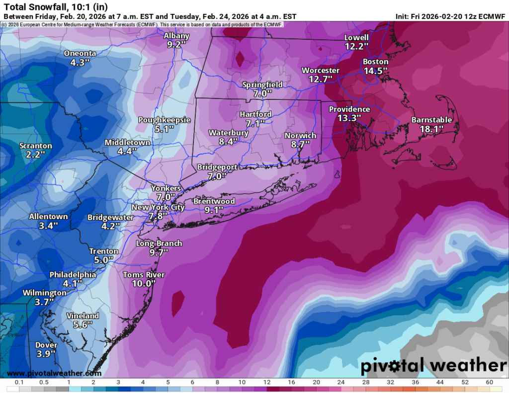
For our readers further north and west, totals fall off a bit as you head north toward the Hudson Valley and into Connecticut.
Snowfall totals alone don’t tell the full story here. Wind gusts are expected to exceed 50 mph, combine that with heavy snow rates, you get blowing and drifting snow, whiteout conditions, and potentially zero visibility for periods during the storm. Blizzard conditions appear likely for much of the area. Do not plan to be on the roads Sunday evening or overnight into Monday.
Timing
Some light snow may arrive as early as late Sunday morning, but the core of the storm kicks in Sunday afternoon. Heavy snow and peak winds continue through the overnight hours, with the storm winding down by Monday morning.
As of now, my forecast is for 15–20″ area-wide, acknowledging that the GFS and NAM are suggesting the potential for more. If those models verify, totals above 20″ are entirely possible, particularly across Long Island and the metro. The Euro’s 12″ keeps the lower end in play, but at this point the weight of the evidence supports a major storm.
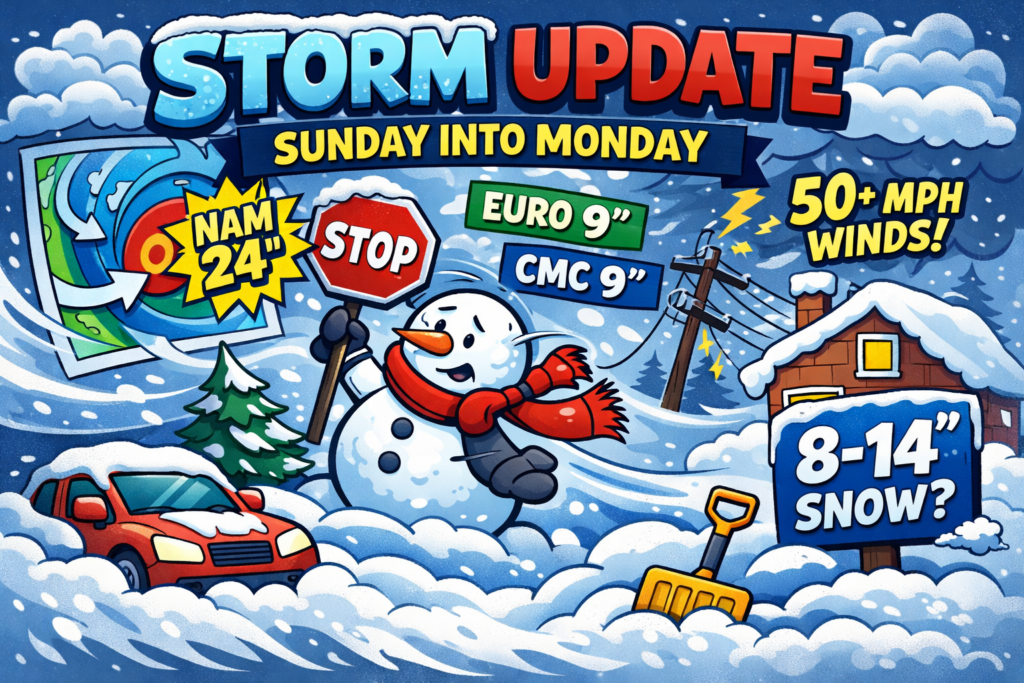
I know many of you have been wondering why I haven’t posted an update about the storm that will impact our area on Sunday into Monday. To be honest, this one caught me by surprise. As recently as last night, only the GFS was signaling a major storm for our region. Every other model had this tracking out to sea, so I held off. Overnight, that changed dramatically.
The model consensus has done a dramatic about-face, and now the GFS is no longer the odd one out.
TLDR; Expect 8-14″ of snow area-wide with the potential for far more if the NAM and GFS are correct. Snow develops Sunday afternoon and continues through the overnight hours, winding down by Monday morning.
Here’s where things sit as of the latest runs:
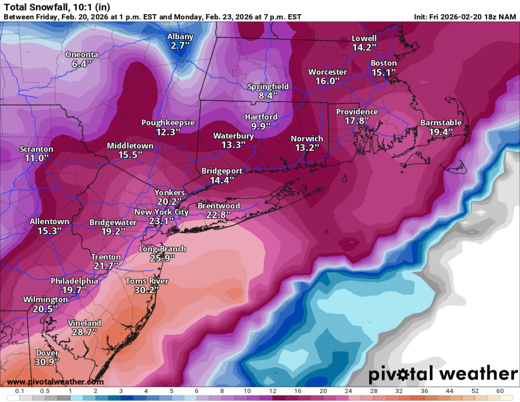
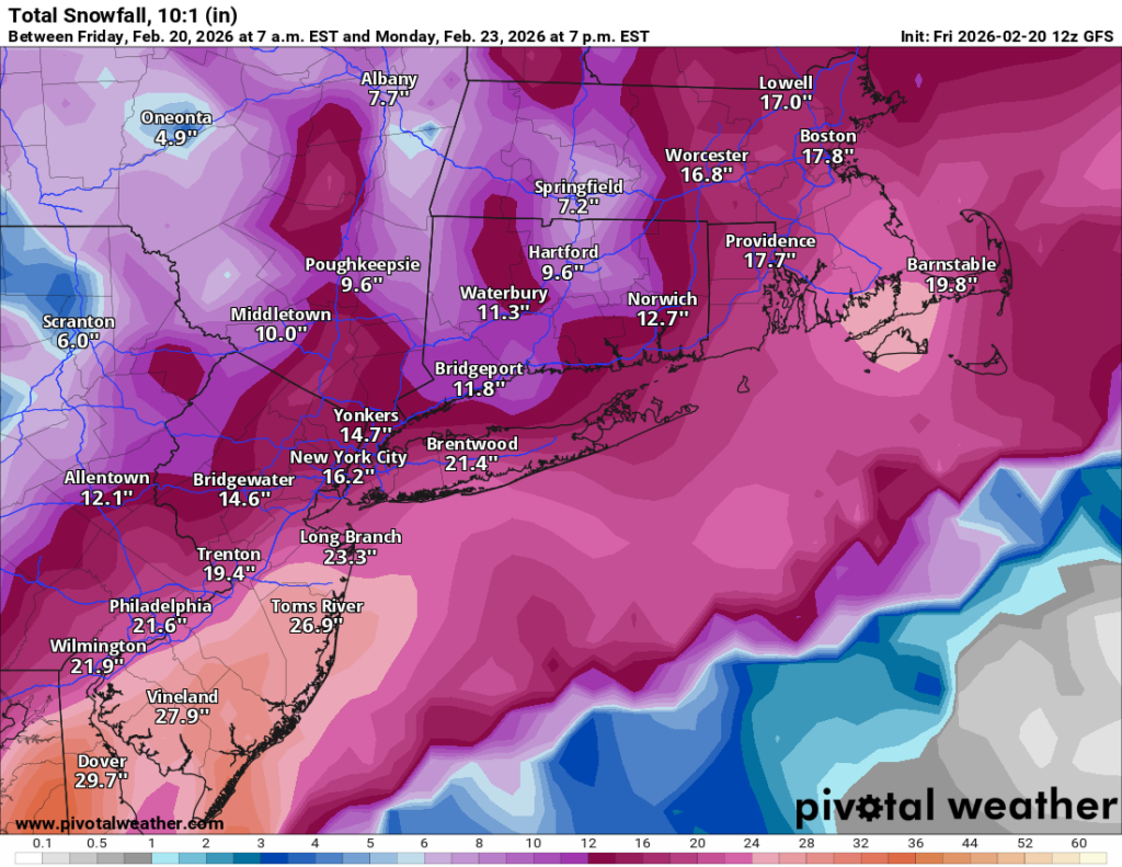
GFS / NAM: The aggressive camp. The NAM just came in showing 24 inches, which is an eye-popping number that demands attention. The GFS has been the drummer beating this storm into existence all along and continues to support a major event.
Euro / CMC: More conservative, both sitting around 9 inches. The Euro in particular has a strong track record with systems like this, so that number keeps the high-end scenario from being a sure thing. BUT the Euro also was insisting on this going out to sea as recently as last night. So it may be VERY wrong on this one.
The spread between 9″ and 24″ tells you everything you need to know about confidence levels right now: this is a rapidly evolving, low-confidence forecast. Trends are moving in the higher direction, but we’re not there yet.
Snowfall totals are only part of the story here. Models are in solid agreement that wind gusts will exceed 50 mph during this event, which opens the door to blizzard conditions for a period of several hours. Blowing and drifting snow, near-zero visibility at times, and the kind of conditions that make travel not just difficult but dangerous. This is worth taking seriously even if you end up in the lower end of the snow range.
Given the aggressive model trends but the still-meaningful Euro/CMC signal, I’m going with 8 to 14 inches area-wide for now, with the possibility that the higher end of the NAM/GFS scenario is entirely possible if that solution verifies.
Right now this is a very low-confidence forecast and I’ll be updating as new runs come in. Do not finalize your plans or prep around these numbers just yet — watch for updates over the next 24 hours as the picture sharpens.
Bottom line: there’s a real storm coming. How big? Still being decided. Stay tuned.
Sorry for the lack of posts today, kids have kept me very busy.
My overall thinking on the storm remains the same. Expect 6-10” of snow area wide. For LI and city snow is likely to change over to sleet around 6-8PM and it will sleet for several hours at least. Sleet accumulation may be as much as 2-3” which will make shoveling very difficult. There may be some additional snow at the end of the storm as well before sunrise Monday.
After the storm the coldest air of the winter will filter in to the region. Lows may go below zero with highs in single digits to low teens.
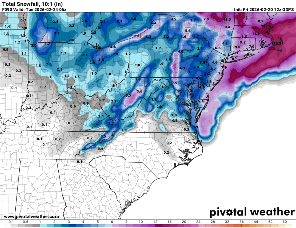
Here’s the latest update on the storm that will impact our region on Sunday:
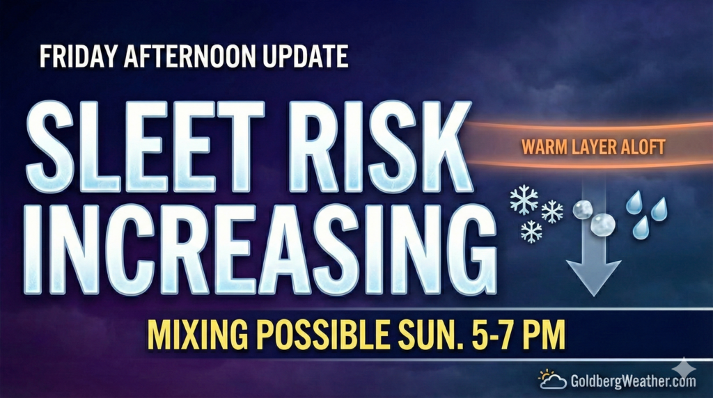
This afternoon’s model runs are starting to hint at a warm layer aloft, which would mean sleet mixing in later Sunday. The problem is the models still don’t agree on how soon that happens or how much sleet we actually see.
GFS / RRFS hold the mix off longer, which would support higher totals (10–15″).
NAM / RDPS / ICON bring mixing in earlier, which knocks totals down into the 5–10″ range.
In terms of timing, snow overspreads the area around sunrise Sunday, continues through the day, and then we watch for a possible change to sleet around 5–7 PM.
Right now I’m leaning toward the changeover happening, and that would cap snow totals. Models also show a pretty meaningful amount of sleet, so at the moment I’m going with 4–8″ of snow area-wide plus a significant sleet layer on top, expect higher totals north and west of the city where mixing is less likely.
One important note: that warm layer is very shallow and barely warm enough to changeover to sleet, only about 1–2° above freezing. So a small shift over the next 24 hours could easily swing us back toward mostly or all snow, and the 10–15″ scenario would come right back into play.
Precipitation should end overnight Sunday night, wrapping up before sunrise Monday (ending southwest to northeast).
Quick update this morning: Most of the overnight models are now showing sleet moving into our area toward the end of the storm. Depending on when that happens it will have an impact on totals. My forecast is now 6 to 12 inches area wide with a question mark regarding the changeover timing. We still need to nail that down. The GFS is currently off on its own showing 10 to 15 inches or more as it does not change over like almost all the others. But winter weather is coming either way.